Off the Ground and Into the River
Before there was Lewis and Clark, there was just Lewis.
Meriwether Lewis was born on August 18, 1774. How fitting that I am publishing this article on his birthday! My roadtrip following his path begins on August 20, 2025, 251 years later and 2 days after his birthday. The famous expedition began in 1803, when he was just 29 years old. My pursuit of the trail will begin on the south side of the Ohio River, near Cincinnati. Before they ever reached Cincinnati, however, there was a massive amount of preparation, planning and activity in Virginia, Pennsylvania and Washington. That’s what this article is about. It is an important part of the history that I felt shouldn’t be excluded.
How and why did this expedition happen? Those of us who went to school in the United States had history books that included something about Lewis and Clark. How much do we remember? How important was this trip? What was the impact on the development of the United States and all the events that came after? For me my knowledge was almost zero when I decided it would be a good idea to make their trip the foundation for my own trip 222 years later.
Much has been written about this expedition over the years, including contemporaneously with the voyage itself as well as in the decades and centuries after it ended. The extensive and meticulously kept journals of the two leaders, as well as letters and journals from a number of the other men who were part of the journey, provide a wealth of original source material which has been mined extensively by scholars and researchers. This research has led to many written and dramatized accounts that have romanticized, summarized, annotated, and used those historical events as fodder for all sorts of historical and cultural interpretation. Despite the voluminous written record and the many artifacts that remain, there is still much we don’t know and probably never will.
What I am doing is in no way unique. I will be joining the hundreds or perhaps thousands who have travelled all or a portion of the trail over the years. There are many guidebooks to help roadtrippers make the most of their attempt to find the trail and experience a little of what the people on that expedition did. I’m grateful for the helpful resources out there. As a solo, older, traveler I feel more confident that I can do this, knowing that I am but one of many who have come before me.
What follows are a few tidbits of information that will provide some background and context for the articles that I will be writing while traveling.
Lewis and Jefferson
Before I started doing my research, I had no memory of when this expedition took place, why Lewis happened to be the person chosen to lead it, or how it unfolded. I’m sure when I was in school I simply memorized names and dates so that I would pass the tests. Nothing stuck.
Turns out that Lewis and President Thomas Jefferson were good buddies. Their families lived on neighboring plantations and circulated in the same social circles while young Meriwether was growing up. When Lewis was in his twenties, Jefferson brought him into the White House to serve as his personal secretary for several years. So Lewis was in his shadow as Jefferson was wheeling and dealing with Congress to get the authority and money to support the expedition. When the money finally materialized, Lewis was literally right under the nose of Jefferson, who I suspect had been mentoring and observing him closely. Lewis had extensive wilderness experience and had been an officer in the military before he went to work in the White House, and Jefferson had the chance to witness and shape Lewis’s character, demeanor, leadership qualities, organizational skills, and all the other traits needed to lead an expedition such as this. At the end of the day it was probably an easy choice. For Lewis, a perfect example of being in the right place at the right time with the right skills. He was eager to lead this exploration and lobbied hard for the job.
Timing is Everything
When the expedition officially launched in 1803, it was the end result of many years of lobbying and strategizing by Jefferson. Even before the Revolutionary War ended Jefferson was obsessed with his desire for the newly formed United States to lay claim to the lands in the west before the British or French or Spaniards established permanent rights to the area. When he became President, this desire intensified. He wanted to make sure that the United States extended from the Atlantic to the Pacific, and needed to know all he could about what lay in between.
Jefferson knew he needed a clear and compelling reason to justify the expedition he had in mind if he was going to get financial support from Congress. Years earlier Jefferson had tried using private investors to finance the expedition but this had not ended well. The leader of that journey did not complete it, and in fact was exposed as a French spy. This time around Jefferson wanted Congress to endorse the trip and put up the money it would require. To convince them he emphasized the need to explore a route west that would reveal navigable trade routes all the way to the Pacific. In addition, he pointed out the need to begin the relationship-building with the local inhabitants that would be necessary to establishing trading posts along the route.
By emphasizing commerce and downplaying the geographic and scientific aspect of the voyage, which is what he was actually most interested in, Jefferson easily got the support he needed to make the trip happen. The money was approved and appropriated on January 18, 1803. It is noteworthy that the rationale for approving the appropriation centered on the desire to expand colonialism to this vast territory with the expectation that there was a lot of profit to be made along the new trade routes. This was the beginning of a long legacy of profiteering by the U.S. government at the expense of the local inhabitants. Not so different today…

The Louisiana Purchase included way more than the present-day state of Louisiana.
After the approval from Congress, Jefferson and Lewis began the initial planning for the journey, aware that they would be exploring territory claimed and controlled by France. That part of the trip would be tricky and require diplomacy so as not to ruffle international feathers, and they strategized accordingly. As it turned out, their worries were unfounded because on July 4, 1803, while Lewis was deep in the weeds of gathering his supplies and men, it was reported that Napoleon had sold the entire Louisiana territory to the United States. This was important because up to that point, Jefferson’s primary goal in the negotiations had been limited to gaining control over only New Orleans. By acquiring the entire territory, the United States now controlled all the land that the expedition would be crossing, and Napoleon, for his part, didn’t have to worry about how he was going to defend it (which would have been quite difficult). Of course, this purchase took no account whatsoever of the claims and rights of the people who already lived there (and I will talk about this in future articles), but for Lewis, the purchase meant it would be smoother sailing without the French challenging them.
Purpose of the Expedition
Once he had the money in hand and the voyage was approved, Jefferson could turn Lewis loose to conduct all manner of exploration way beyond the confines of commerce and trade. But to achieve Jefferson’s mandate Lewis, who had very little formal education, had to take several crash courses in astronomy, map-making, geography, botany, geology, medicine and biology. He also had to learn how to use all the tools and technology available to operate various instruments and take appropriate measurements. Jefferson created a laundry list of instructions on what the expedition was to explore and discover. This was literally uncharted territory, and no one in the east had any idea what lay to the west, or how it differed from the landscape they were already familiar with. Specifically, Jefferson’s instructions to Lewis included the following:
Find an all-water route to the Pacific.
Ascertain the fertility and extent of the territory surrounding the Missouri River and whether it is “susceptible of a large population,” a not-so-subtle reference to future white settlers descending on the region.
Assess the species of timber, annual rainfall, temperature extremes, and soil fertility with an eye to whether the region will support agriculture (again contemplating westward expansion of settlements).
Take careful observations of latitude and longitude, as well as all river systems encountered, including falls, rapids, objects and natural markings.
Learn the names of the Indian tribes and their nations, their numbers, their possessions, their relations with other tribes, their languages, traditions, occupations, implements and tools they use, food, clothing, housing, diseases and remedies, laws and customs, and opportunities for commerce.
Discover flora and fauna - plant and animal life - as well as minerals such as limestone, coal and salt.
Preparations
When I think about how I’ve gone about preparing for my own departure on August 20, I am limited only by my own failure to ask the right questions. All the information I need is out there. I just hope I’ve thought of everything. For example, I learned just a few days ago that beginning October 1, certain roads in British Columbia require all vehicles to have snow tires on all four wheels. Who knew? I had to scramble for a couple of days to figure out the best way to make that happen before I enter Canada in late September. Or did you know that the Centers for Disease Control now require a certain form before you can take your dog back into the United States? I didn’t, and apparently just having the up to date vaccination record is not enough. So I raced around the internet to verify that this was indeed a “thing” and made sure that I have the form, which had to be submitted online to the CDC and returned certified by them. Whew! I also have the luxury of knowing that any supply item I forgot to pack or discover that I need can easily be had by heading to the nearest Walmart.
But for Lewis, who was the sole person in charge of putting the entire expedition together, there was no information about what hardships they might encounter, how long they would be gone, what sicknesses might afflict them, or any number of other surprises. As the saying goes, “you don’t know what you don’t know.”
How do you calculate the supplies you will need when your starting point for information is almost zero? How many weapons and how much ammunition? How much food, especially the kind they couldn’t get on the route (flour, beans, other dry goods)? How much whiskey for the men? What trinkets and beads and other objects should they take for negotiating with the Indians for supplies along the way, and how much of each item? They had no clue how many people they might encounter, what languages they spoke, or whether they would be friendly or hostile to the visitors. What scientific instruments and measuring devices would be needed? How would they keep those instruments in good working order for the duration of the trip? What about spare parts for anything that breaks? How many axes, knives, clothing, shoes, camping equipment and paraphernalia? What about medicines? There would be no doctor on the trip, so Lewis had to become versed in the medicines of the day and how to administer them. And let’s not forget all the paper and ink that would be needed for documenting the trip, recording his findings, and writing letters and reports to Jefferson. How would they keep everything dry when on the river or dealing with rainstorms? And on and on. Lewis had to plan for all of it. Once they left St. Louis, they would be on their own.
Gathering Supplies
Harper’s Ferry, West Virginia, located at the confluence of the Potomac and Shenandoah Rivers, was a key source of supplies for Lewis. We know this because he kept meticulous records of every single item he ordered. That’s where the national armory and arsenal were, and that’s where he procured all the munitions he thought they might need, among other things. He also commissioned a special collapsible boat that he thought might come in handy at some point. It was quite intricate in design and its construction ended up delaying the voyage by several weeks.

The commissioned boat was quite innovative for its time.
The expedition did attempt to assemble and use the boat during the trip. Sadly, it did not live up to expectations, taking on water as soon as it was launched. It sank and was left behind somewhere on the trail.
I visited Harper’s Ferry this summer, just to get a sense of where it was and what it might have been like to be there in 1803. Officianados of mid-19th century American history will also recognize Harper’s Ferry as the site of a pivotal moment in the events leading up to the Civil War. It was here that John Brown, a white man from New England, made it his personal mission to lead a rebellion against slavery in 1859. An active abolitionist for much of his adult life, he chose Harper’s Ferry as the launch site for this rebellion because of the armory, which he thought he could either control or destroy. Much has been written about Brown’s failed attempt to take over the armory, but suffice it to say that he was probably doomed from the beginning and the entire episode was over within 36 hours. He was unable to recruit the numbers of people needed for such an undertaking, and the African Americans living there at the time, many of whom, if not most, were enslaved, were understandably reluctant to join the effort knowing what the consequences would be for them and their families if it failed. The short-lived rebellion was added to the list of events and skirmishes that led to the full blown outbreak of the Civil War in 1861.
Bringing in Clark
As Lewis gathered all the supplies he would need for the journey and had them sent to Pittsburgh, which was the official starting point, he also continued his studies with various experts and scientists of the day, gathering the knowledge he would need to fulfill President Jefferson’s detailed list of instructions. During all these preparations, the size and scope of the expedition continued to expand, and Lewis realized he would need a partner to help him lead the men, make important decisions, and manage the supplies and movements. He knew William Clark from his days in the military. They were a few years apart in age, and did not know each other well, but during the short time they had served together had apparently instantly bonded over their love of the wilderness, exploration, strategy and military life. Their shared values and extensive wilderness experience made him the perfect choice.
Upon receiving Lewis’s invitation to share leadership of this expedition, Clark jumped at the chance to participate. Theirs was a partnership in the truest sense of the word, and they shared all responsibilities and decisions equally.
Clark was staying across the river from Louisville, Kentucky, in Clarksville, Indiana, named after William’s brother George Rogers Clark. The plan was that while Lewis gathered the supplies and loaded the boats in Pittsburgh, Clark would recruit more men and be ready to join the expedition when the boats arrived.
The Launch
Lewis’s plan was to leave Pittsburgh and follow the Ohio River to the Mississippi, picking up Clark and the additional recruits along the way, then travel to St. Louis, where they would begin the true uncharted part of their trip west up the Missouri River.

Pittsburgh probably didn’t look much different than this in 1803.
Pittsburgh is located at the confluence of the Ohio, Allegheny, and Monongahela Rivers.
I happened to be in the neighborhood of Pittsburgh this summer, so stopped there to see what the confluence of three rivers looks like. I tried to imagine the scene with no buildings, skyscrapers, bridges or concrete. It was a little difficult, to say the least. But the flow of the river hasn’t changed, so when I focused on that and shut out all the distraction around me I could almost see them shoving off and starting down the Ohio River.
The party got a much later start than intended because their big barge took much longer than expected to complete. Once they finally departed Pittsburgh on August 31, they ran into trouble almost immediately. The delays caused by the boat builders resulted in less than optimum conditions for traveling down the Ohio in late summer. By the end of August when they finally shoved off, the water level had receded substantially and was very low in many places. It was slow and difficult for this large party to make progress in those early weeks of the journey.
One of their first stops along the way was Wheeling, West Virginia, where they stayed two days. Woohoo! That’s the city where I was born! I was able to stop in Wheeling when I drove through in July and saw the city and the Ohio River up close. While there I learned that Wheeling was the capital of Pro-Union Virginia in the lead-up to the Civil War, there being no West Virginia at that time. I just love learning little tidbits like this! (and I have to include it here because these little factoids fly right out of my brain as soon as I learn of them if I don’t write them down somewhere)
As I gazed at the river in 2025 I tried to imagine Lewis and his party of boats, men, horses and supplies making their way slowly down the river in 1803, encumbered by low water and the need to keep getting out, lightening the boats, walking on the banks, then getting back in when the water was deep enough to support the heavy loads again. Arduous and difficult, but that’s what they all signed up for, so they persevered until the Ohio waters became more navigable further on.
Clarington, Ohio
Another little fun fact I discovered when I was doing my research about the early days of the expedition, was that Lewis and his men passed right by the town of Clarington, Ohio, which is just down the river from Wheeling. There is no evidence that they stopped, but they surely would have been seen by the residents who lived there at the time. I can just imagine what an amazing spectacle it must have been for the people on the banks of the river to see the big barge coming, accompanied by smaller boats and canoes, and then passing right in front of them before disappearing around the bend.
Clarington is only significant to my story because it is the small town where my family lived in the years just after my father completed his seminary studies. This was his first job, serving a small, rural parish where he worked with other small churches in the area to help families survive and find community in that poverty-stricken environment. Our house was located right on the riverbank overlooking the Ohio River, and we have old movie reels of my dad sweeping the water off our sidewalk and away from our back stairs, a task that was necessary every year when the river would flood.
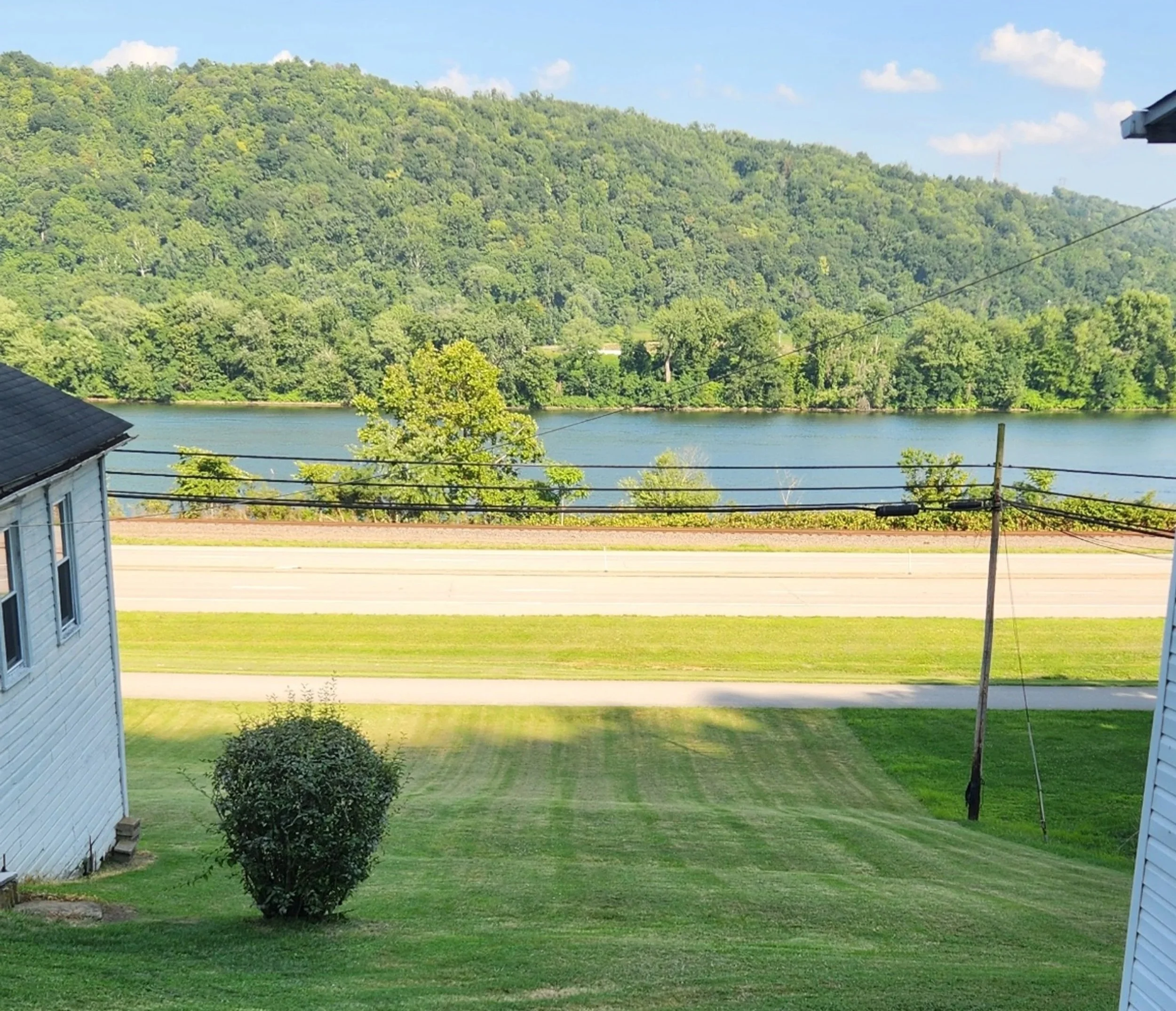
In the middle of this picture, in the middle of the road, you can imagine the house my family lived in back in the mid-1950s. You might have to close your eyes to see it properly. My brother Sam used to play on the hill where I’m standing. All the houses sitting on the banks were destroyed when the road was built.
Clarington was not incorporated as a village until 1847, but was settled as early as 1798, so there would have been some white families living there in 1803. Of course there would have been a number of native families also living in the area, and perhaps some black families as well. Apparently, the official border of the Mason-Dixon line, which separated the slave states from non-slave states, was just a few miles south of Clarington, establishing it as a free settlement. In the mid-1800’s Clarington made a name for itself when it got into the steam packet boat building business. The town was thriving for a number of years extending into the early 20th century and grew to as many as 1500 residents. Once the boat-building industry declined in importance, the town declined as well and as of the 2020 census, had only 280 residents.

This is what flooded Clarington looked like in the 1950’s. That’s my mother in the white scarf, and my dad’s church behind her. She is probably standing near where the road was built after all the buildings, including the church, were torn down.
I had not been back to Clarington in many, many years, and moved away when I was only two, so I have no memories of living there. That said, there is something about standing in the place where your roots began. I’m not sure what it is, but visiting my birthplace and then adding in the context of Lewis and Clark, brought forth something within me. Can’t explain it, but I felt something.
Next Steps
I leave it to the scholars who have devoted their entire careers to this expedition to offer a more complete record and professional perspective on Lewis and Clark’s epic journey. In conducting my limited research I have barely scratched the surface of the information that is available to the general public about this voyage and the men who participated in it. As I traverse the trail, I will be visiting interpretive centers and museums that will add depth and texture to my present-day experience. My articles will digest and share the information I learn through the lens of a distinct nonexpert, someone who has her own unique perspective when it comes to understanding and interpreting our controversial history of westward expansion. I am but a humble retiree with curiosity in her brain and who happens to own a campervan. My thoughts, reflections and experiences will be my own.
To me, this is fascinating stuff, and I hope you find it interesting as well.
My next blog will be from the road. Don’t know when. The articles during my two month trip will no doubt be sporadic and unpredictable. If you want to know when I’ve posted something, you can subscribe and then you will get an email notice.
Happy Trails!
Resources
Most of the information I will be sharing about Lewis and Clark and their expedition comes from these sources. As I write articles along my route I will add information from the various museums and information centers I encounter.
Ambrose, Stephen E. (1996). Undaunted Courage. Simon & Schuster Paperbacks.
Discover Lewis and Clark. https://lewis-clark.org/
Fanselow, Julie. (2003). Traveling the Lewis and Clark Trail, 4th Ed. Morris Book Publishing, LLC.
Josephy, Alvin M., Ed. (2006). Lewis and Clark Through Indian Eyes: Nine Indian Writers on the Legacy of the Expedition. Vintage Books.
Moulton, Gary E. (2003). The Lewis and Clark Journals: The Abridgement of the Definitive Nebraska Edition. University of Nebraska Press.